Il Lago di Vadimóne
Vadimóne Lake

clip video italiano
English video clip
A questo territorio è strettamente connesso il crepuscolo della civiltà etrusca in quanto, nel 309 e nel 283 a.C., proprio qui si tennero le due famose battaglie, cosiddette del Lago Vadimóne, attraverso cui nel giro di pochi anni Roma sancì il suo definitivo predominio sull’Etruria.
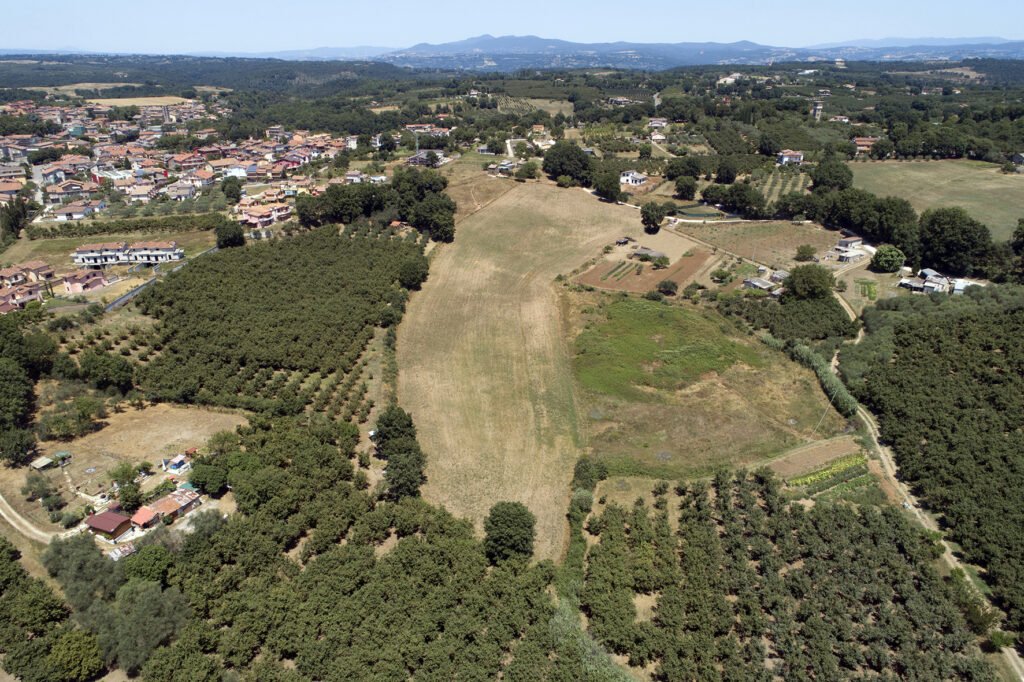
È infatti stato dimostrato che questo leggendario specchio d’acqua, per oltre un secolo “forzatamente” associato ad uno sinkhole della Piana di Lucignano, nel territorio di Orte, sia invece da individuare con questa vasta conca, oggi asciutta, nei pressi dell’abitato di Vasanello, da sempre nota come “Poggio del Lago”.
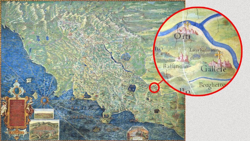
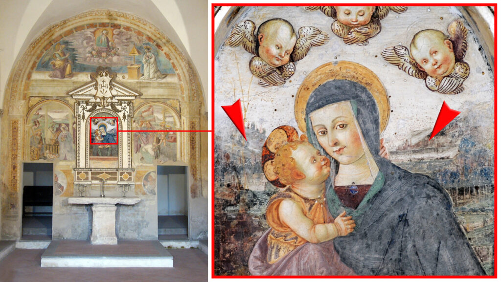
Oltre al toponimo e alla geologia, ad evidenziare la presenza di questo lago esistono numerose carte geografiche antiche: emblematica quella dell’Etruria realizzata nel 1581 dal grande topografo Ignazio Danti nella Galleria delle Carte Geografiche in Vaticano. Notevole il riscontro fornito da un affresco realizzato nel XV secolo nell’edicola interna della chiesetta di Santa Maria delle Grazie: alle spalle della Madonna con Bambino spicca infatti un lago, la vera e propria fotografia di un elemento paesaggistico evidentemente ancora così tipico, nella Bassanello di fine Quattrocento, da indurre l’anonimo pittore a sceglierlo come sfondo della composizione sacra. Insomma, a Vasanello un lago c’era eccome… ma ce l’aveva un nome?
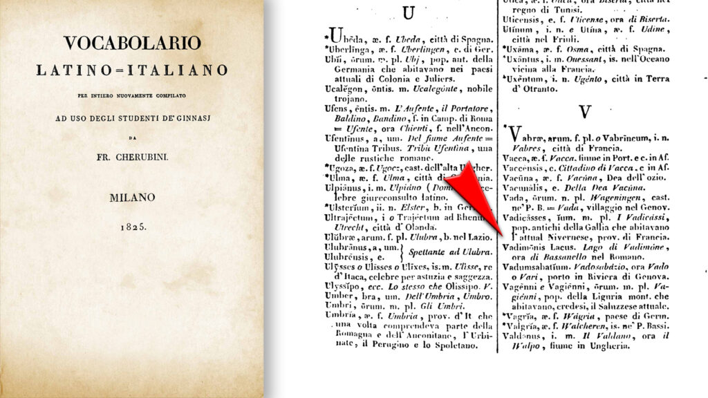
Certo che sì, perlomeno fino al 1825, come appare evidente, ad esempio, nel vocabolario di Francesco Cherubini che alla voce Vadimōnis Lacus recita: “Lago di Vadimone, ora di Bassanello nel Romano”. Poi, intorno alla metà dell’800 è accaduto “qualcosa” ed ecco allora la vera domanda da farsi: come ha fatto il Vadimóne a “traslocare” ad Orte?
Lo spiega un libro del giornalista-saggista Ardelio Loppi, “Il Lago Vadimóne si trovava a Vasanello”, pubblicato dal Gruppo Albatros nel 2022.
The twilight of Etruscan civilization is closely connected to this territory, as it was here, in 309 and 283 BCE, that the two famous battles known as the Battles of Lake Vadimone took place. Through these clashes, Rome decisively established its dominance over Etruria within just a few years.
It has been proven that this legendary body of water—mistakenly associated for over a century with a sinkhole in the Lucignano Plain, within the territory of Orte—should instead be identified with this vast, now-dry basin near the town of Vasanello, long known as Poggio del Lago (Hill of the Lake).
In addition to the toponym and geological evidence, numerous ancient maps highlight the presence of this lake. One particularly emblematic example is the 1581 map of Etruria created by the great topographer Ignazio Danti for the Gallery of Maps in the Vatican. Further confirmation comes from a 15th-century fresco inside the small Church of Santa Maria delle Grazie: behind the Madonna and Child, a lake stands out—essentially a photographic depiction of a landscape feature that must have still been so characteristic of late-15th-century Bassanello that the anonymous painter chose it as the backdrop for the sacred composition.
In short, there really was a lake in Vasanello… but did it have a name? Absolutely—at least until 1825, as evidenced, for example, by Francesco Cherubini’s dictionary, which under Vadimōnis Lacus states: “Lake Vadimone, now of Bassanello in the Roman territory.”
Then, sometime around the mid-19th century, something happened. And this leads to the real question: how did Lake Vadimone “relocate” to Orte? The answer is explored in a book by journalist and essayist Ardelio Loppi, Il Lago Vadimóne si trovava a Vasanello (Lake Vadimone Was in Vasanello), published by Gruppo Albatros in 2022.